
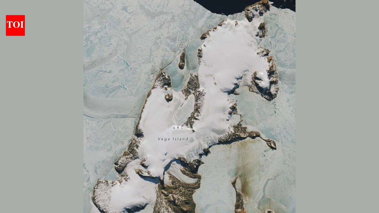
NASA satellite images show Vega Island in Antarctica shaped like a giant skull. The October 10, 2026 view reveals more bare ice after an unusually warm winter. Glaciologist Mauri Pelto said, "The winter season was no treat for these glaciers." The dark ice now absorbs more heat than bright snow.
From high above the Weddell Sea, Vega Island appears to be staring back at Earth. NASA's latest satellite images show a section of the ice-covered Antarctic island shaped like a grinning skull in profile, complete with a rocky eye socket, a dark glacial mouth and a jawbone formed by ice. But beneath the striking visual is a more serious message: the October 2026 image reveals unusually large areas of bare ice after a warmer-than-average Antarctic winter, according to NASA Earth Observatory.
A skull made by nature
Vega Island lies east of the Antarctic Peninsula, a remote and ice-bound outpost in the Weddell Sea. From the right angle, its natural features combine into an unsettling likeness of a human skull looking toward nearby Devil Island. A nunatak, a rocky peak protruding through the ice, forms the eye socket, while a lateral moraine creates the appearance of a mouth. Bahía del Diablo, or Devil's Bay Glacier, supplies the jawbone.NASA Earth Observatory published the comparison on 30 October 2026, using images captured by the Operational Land Imager on Landsat 9. The earlier image, taken on 22 March 2025, shows the island near the start of the austral autumn, when a layer of seasonal snow covered much of the ice.
The newer image, acquired on 10 October 2026, shows a very different surface, with large grey areas where snow has disappeared and darker bare ice is exposed.
The effect is powerful because the skull is not a single landform but a collection of ice, rock and debris arranged by nature. In the 2025 view, snow softens the features and makes the island look more uniformly white. In the 2026 view, the exposed ice sharpens the "face," making the eye socket and jaw appear more pronounced.
Why more ice is visible
Glaciologist Mauri Pelto of Nichols College told NASA that above-average temperatures during the 2026 winter, particularly in June, helped explain the unusually extensive bare ice. Limited new snow accumulation over the winter, combined with sublimation and wind scouring, left more of the glacier surface exposed by October. "The winter season was no treat for these glaciers," Pelto said.That matters because bare ice behaves very differently from snow. Snow is bright and reflects much of the Sun's energy back into the atmosphere, while bare ice is darker and absorbs more solar radiation. As Antarctic days lengthen and temperatures rise into the melt season, that darker surface can accelerate melting, creating a feedback loop in which exposed ice warms faster and loses mass more quickly.Pelto noted that even a thin spring snowfall would help in the short term by insulating the glacier surface. But if the ice remains exposed, the skull-like features may gradually change. "When entombed in snow and ice, the skull is preserved," he told NASA. "But when exposed to melt, it weathers away, which will lead to a changing jawline and expanding eye socket."
A longer record of retreat
The skull may look new in satellite imagery, but scientists have been studying Vega Island's glaciers for decades. The first comprehensive mapping of its ice was supported by early Landsat observations, aerial photographs and topographic maps. A study published in 1982 catalogued 29 glaciers on the island and described its four ice caps, rocky cliffs and outlet glaciers.
One of those glaciers, Devil's Bay Glacier, has been monitored closely since the austral summer of 1998 to 1999. Researchers have measured an overall decline in its mass over that period. Satellite images from recent decades also show ice loss from other glaciers on Vega Island, alongside an increase in exposed bedrock.In other words, the October 2026 image is not simply a seasonal snapshot. It fits into a longer pattern of change on the Antarctic Peninsula, where warming conditions, reduced snow accumulation and longer exposure of glacier ice can combine to alter the landscape over time.
An island with a dramatic past
Vega Island's eerie appearance has an echo in its exploration history. During the Swedish Antarctic Expedition of 1901 to 1903, teams studying the geography, geology, climate and wildlife around the eastern Antarctic Peninsula became separated into three groups. They spent a winter isolated in different locations after their ship was lost to pack ice.
Cape Well-met, off what looks like the forehead of the island's skull, became the site of a reunion between two of those groups in the spring of 1903. Soon afterwards, an Argentine expedition rescued the survivors. The name of the cape reflects that moment of relief after a prolonged and dangerous ordeal.
What the image tells us
The skull-like island is a reminder that satellite imagery can reveal both beauty and warning. The visual is created by ordinary glacial processes, but the growing extent of bare ice points to conditions that could make the coming melt season more intense. NASA's images show that Vega Island's "face" is not fixed; it changes as snow arrives, melts, blows away or fails to accumulate.For scientists, the value lies in the detail. Landsat allows researchers to compare the same landscape across seasons and years, tracking snow cover, glacier extent and exposed rock. For everyone else, the image offers a vivid way to understand a distant corner of Antarctica: an island that looks like a skull, and whose changing surface may reveal how its glaciers are responding to a warming climate.NASA's new satellite images show an Antarctic island that looks like a giant skull, with a rocky eye socket and glacier jaw; the October 2026 view reveals more bare ice after an unusually warm winter