
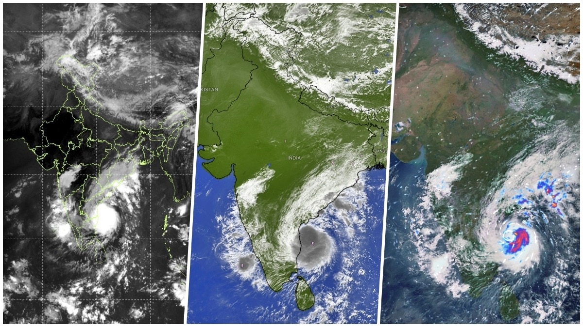
Severe Cyclonic Storm Murasu is moving towards the Andhra Pradesh coast. Three satellites are tracking the storm as it gathers strength over the Bay of Bengal. The India Meteorological Department expects landfall between 11:30 pm on November 2 and 4 am on November 3, bringing heavy rain and strong winds.
Powerful Cyclone Murasu is closing in on India's east coast, with satellite images capturing its swirling cloud bands and organised storm structure over the Bay of Bengal.
Severe Cyclonic Storm Murasu is moving towards Andhra Pradesh, threatening to bring destructive winds and heavy rainfall to coastal districts as it prepares to make landfall.
Images captured by India's INSAT-3DS satellite, alongside international satellite-monitoring platforms, show the storm's vast cloud mass and its circulation over the west-central Bay of Bengal. The different views offer meteorologists a picture of the cyclone's structure, movement and associated thunderstorm activity as it approaches land.
The INSAT-3DS thermal infrared image, captured between 10 am and 10:27 am IST on November 2, shows a dense, bright cloud cluster associated with Murasu over the Bay of Bengal, off the Andhra Pradesh coast. The surrounding cloud bands indicate the storm's organised circulation.
The satellite views also show extensive cloudiness stretching across parts of southern India and the adjoining ocean, highlighting the broad weather system surrounding the cyclone.
According to the India Meteorological Department (IMD), Murasu moved west-northwestwards at around 22 kmph during the six hours preceding 8:30 am on November 2. At that time, the severe cyclonic storm was centred over the west-central Bay of Bengal near latitude 14.1°N and longitude 81.4°E.
The storm was located approximately 160 km east-southeast of Nellore, 180 km northeast of Chennai, 180 km east-southeast of Kavali and 210 km southeast of Ongole. It was also around 240 km south of Machilipatnam.
The IMD has forecast that Murasu will continue moving northwestwards and cross the south Andhra Pradesh coast as a severe cyclonic storm between Nellore and Narsapur, south of Ongole. Landfall is expected between 11:30 pm on November 2 and 4 am on November 3.
At landfall, the system is expected to pack sustained wind speeds of 100-110 kmph, gusting up to 120 kmph.
The approaching cyclone comes less than a week after Cyclone Arnab affected parts of India's east coast, putting disaster-management agencies on alert for another round of evacuations, heavy rainfall and coastal disruption.
Satellite monitoring will remain crucial as Murasu approaches the coastline. Thermal infrared imagery helps meteorologists track deep cloud formations and evolving storm structures, while repeated observations allow them to monitor changes in the cyclone's position and organisation.
For coastal communities, the immediate concern is the approaching landfall, with strong winds, intense rainfall and rough seas expected to pose risks across parts of Andhra Pradesh.