
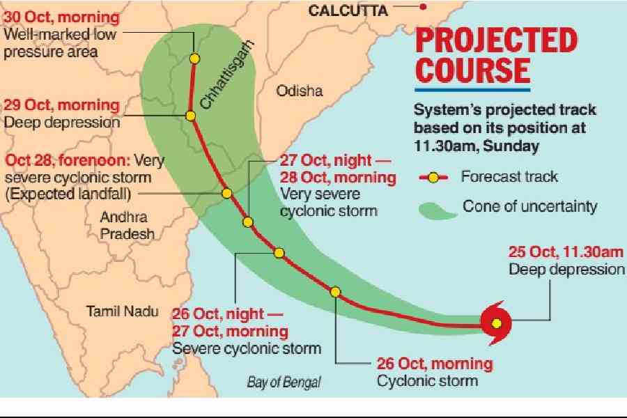
Calcutta may escape Cyclone Arnab's fury as the system moves towards the Andhra Pradesh coast for a Wednesday landfall. The Met office said moderate rain is likely in the city from October 28 to 30. While the storm intensifies, many districts in South Bengal will get strong winds and rain.
A Bay of Bengal system that could develop into Cyclone Arnab intensified into a deep depression on Sunday morning, moving towards the Andhra Pradesh coast, where it is expected to make landfall on Wednesday.
South Bengal is likely to witness strong winds along and off the coast from Tuesday, followed by a spell of rain between October 28 and 30, with heavy rain forecast in some districts.
Sunday status
A low-pressure area over the east-central and adjoining southeast Bay of Bengal intensified into a depression on Saturday evening.
The system moved southwestward at a speed of 5kmph over the preceding six hours and intensified into a deep depression by 11.30am on Sunday, an IMD bulletin said.
Around noon, it was 870km east-southeast of Visakhapatnam.
Intensification
The system is likely to move southwestward and intensify into a cyclonic storm over the east-central and adjoining southeast Bay of Bengal by Monday morning.
It is then expected to move west-northwestward over the east-central and adjoining west-central Bay of Bengal, intensifying into a severe cyclonic storm over the west-central Bay between Monday night and Tuesday morning, the bulletin said.
Thereafter, the system is likely to move northwestward and intensify further into a very severe cyclonic storm, reaching the west-central Bay of Bengal near the Andhra Pradesh coast by Wednesday morning.
Landfall
The system is very likely to cross the Andhra Pradesh and Yanam coasts between Bapatla and Visakhapatnam as a very severe cyclonic storm by the forenoon of October 28 (Wednesday), the bulletin said. Yanam is a coastal enclave in Andhra Pradesh that forms part of the Union territory of Puducherry.
Wind speed
At landfall, Arnab is expected to generate sustained winds of 115-125kmph, gusting to 140kmph, the Met office said.
On Monday morning, when it is expected to intensify into a cyclonic storm, the system could generate winds of up to 100 kmph. Between Monday night and Tuesday morning, as a severe cyclonic storm, it could bring winds of up to 115kmph. It is expected to reach very severe cyclonic storm intensity by Wednesday morning.
Cyclones Yaas (May 2021) and Amphan (May 2020) made landfall in Odisha and the Sundarbans, respectively, as very severe cyclonic storms.
Impact on Calcutta
Light to moderate rain, accompanied by moderate gusts of wind, is likely in Calcutta between October 28 and 30, according to the bulletin.
South 24-Parganas, East Midnapore, West Midnapore, Jhargram, Bankura and Purulia are likely to receive heavy rain.
In north Bengal, Darjeeling, Jalpaiguri, Kalimpong and Alipurduar districts are likely to receive heavy rain between October 29 and 31.
After landfall, the system is expected to move through Chhattisgarh and Madhya Pradesh, weakening as it travels over land.
"The landfall area is too far from here. But a very severe cyclone is a massive system. The clouds from the outer band will cause rain in Bengal," a Met official in Alipore said.
Flights and trains
A Calcutta airport official said the authorities were in constant touch with the Met office.
"As of now, the input we received from the Met office says Calcutta is not likely to bear much of the brunt of the storm. The airport is likely to remain operational. However, flights to and from some destinations, like Visakhapatnam, may get affected because of the storm's impact in those areas," the official said.
An official of South Eastern Railway, which operates trains between Bengal and southern states, said: "As of now, there are no cancellations from Bengal. What happens in the southern divisions remains to be seen."