
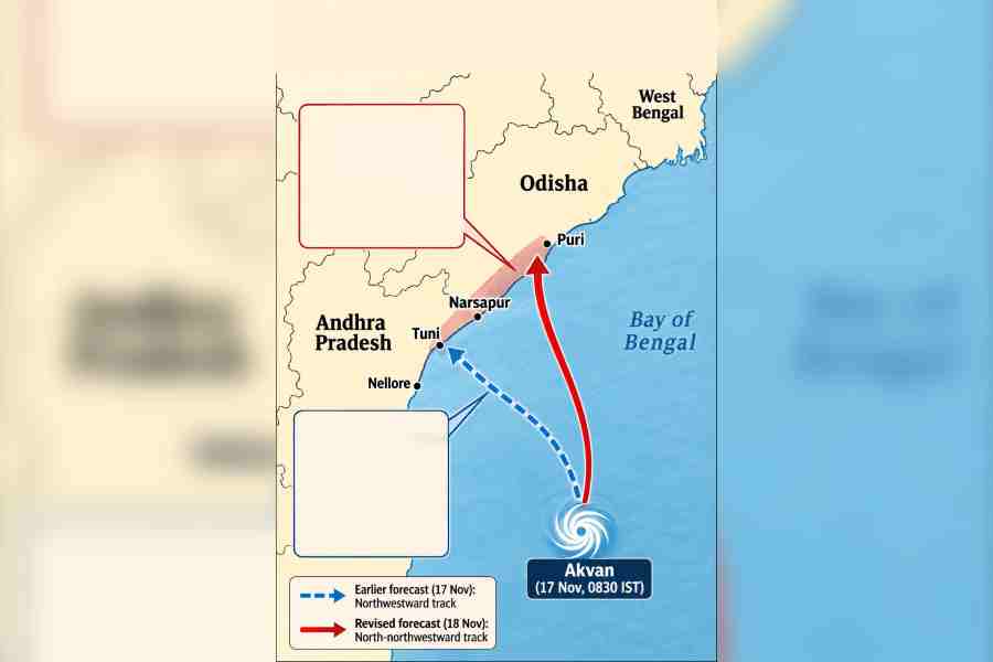
Cyclone Akvan shifted its path, putting coastal south Bengal on rain watch. The Met office said, "The storm will move through Odisha after landfall and come closer to south Bengal than previously expected." Calcutta will get light to moderate rain on Thursday and Friday as the storm loses some intensity.
A slight shift in the projected path of Cyclone Akvan has prompted the Met office to forecast very heavy rain in parts of coastal south Bengal between Friday morning and Saturday morning.
Calcutta is likely to receive light to moderate rain on Thursday and Friday, according to the forecast issued late on Wednesday. The sky remained overcast for much of Wednesday, but there was no rain.
Akvan intensified into a severe cyclonic storm over the west-central Bay of Bengal on Wednesday morning. It is likely to cross the coast between north Andhra Pradesh and south Odisha on Friday afternoon, the Met office said.
Until Tuesday, the Met office had forecast that Akvan would intensify into a very severe cyclonic storm before making landfall in Andhra Pradesh, with peak wind speeds of 145 kmph. However, the system lost some intensity from Tuesday evening and is now expected to cross the coast as a severe cyclonic storm, with winds reaching 110 kmph.
The storm's projected track has also shifted northwards. While Tuesday's forecast showed a northwestward tilt, Wednesday's projection indicated an almost vertical, northward path.
"Earlier, it was expected to hit land in Andhra Pradesh. Now, it is expected to hit land between Andhra and Odisha. The storm will move through Odisha after landfall and come closer to south Bengal than previously expected. Wind speeds will not have much impact in Bengal, but rainfall, particularly in East and West Midnapore, which border Odisha, could be very heavy, up to 200mm in 24 hours," a Met official said.
Between Thursday morning and Friday morning, light to moderate rain or thundershowers are likely at many places in Calcutta, North 24-Parganas, South 24-Parganas, East and West Midnapore, Jhargram, Howrah and Hooghly. Heavy rain is likely at isolated places in North 24-Parganas, South 24-Parganas, East and West Midnapore and Jhargram.
Between Friday morning and Saturday morning, very heavy rain of up to 200mm in 24 hours is likely at isolated places in East and West Midnapore. Heavy rain is also expected at isolated places in South 24-Parganas, Jhargram, Bankura and Howrah.
Around Wednesday noon, Akvan was centred over the west-central Bay of Bengal, about 600 km south-southeast of Kalingapatnam in Andhra Pradesh, the Met office said.
"Continuing to move north-northwestward, it is likely to cross the North Andhra Pradesh and Yanam and South Odisha coasts between Narsapur and Puri by Friday afternoon as a severe cyclonic storm, with maximum sustained wind speeds of 90-100 kmph, gusting to 110 kmph," a Met bulletin said.
The storm remained practically stationary for much of Tuesday evening before moving slowly north-northwestward at 3kmph and intensifying into a severe cyclonic storm in the early hours of Wednesday, a Met official said.
Strong wind shear was among the factors that caused the system to lose intensity.